Around Nanga Parbat Trek
Around Nanga Parbat Trek 2025-26
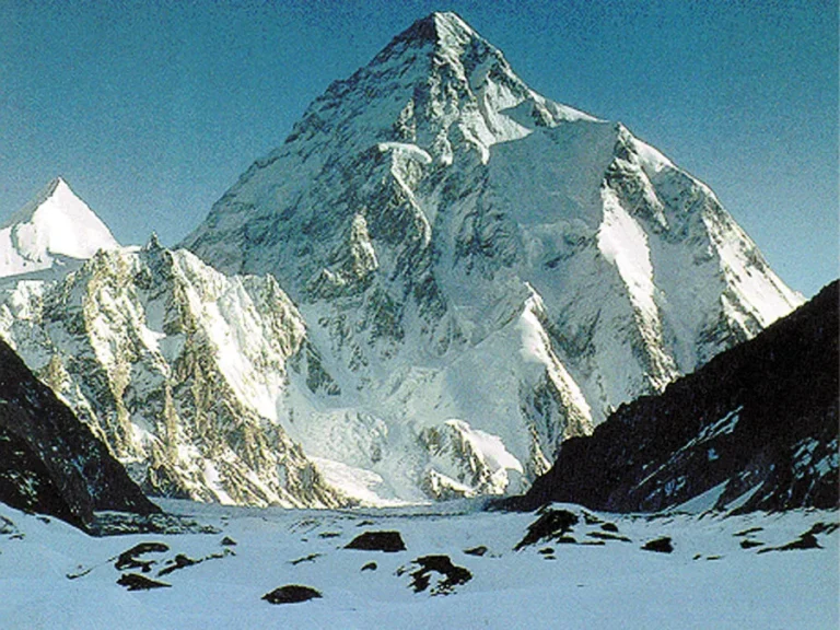
Nanga Parbat is the ninth-highest mountain in the world, an 8,126-meter (26,660 ft) peak in Pakistan’s Gilgit-Baltistan region, known for its name meaning “Naked Mountain” and earning the nickname “Killer Mountain” due to its extreme climbing difficulty and high fatality rate in early attempts. This immense and dramatic peak is characterized by its massive vertical relief, including the world’s highest mountain face, the Rupal Face, and has the fastest-growing rate among the world’s mountains.
Dates and Cost
All seasons are considered good for the Nanga Parbat Trek. Considering the inflow of tourists all year round, our dates are open throughout the year and your bookings will be 100% guaranteed even if you are a single traveler. Our prices and dates for this tour (all seasons) are given below.
- Pickup from hotel or vacation rental before sightseeing
- Drop at hotel or vacation rental after sightseeing
- Guided sightseeing tour according to itinerary above
- Map (hard copy)
- Licensed professional guide (english speaking)
- SUV/mini-van/car (depending on number of people)
- Driver
- All entry/admission tickets
- Bottled water in car (fair usage policy)
- Toll & parking fees
- Drop after 10 pm (Drivers & Guide’s working hours end at 10pm)
- Gratuities/tips for guides/drivers, etc
- Meals, snacks and drinks (our guide will make recommendations after consultation with guests)
- Accommodation (can be arranged at additional cost according to your budget)
- Personal travel insurance (Recommendation/Rescue Partners: Global Rescue)
- Visa to Pakistan (supporting documents can be offered if requested for multiday tours)
- Refunds in case of early tour windup/closure due to any reason
- Anything not mentioned in inclusions
FAQs
Upon arrival in Islamabad, our representative will pick you up from the airport and take to the hotel. We then fly to Gilgit, or if the weather is inclement, we travel by road to Chilas where we will be accommodated in a hotel. Jeeps take us to the end at Buner Dass the last village in the valley. Dass is the beginning of the trek and each night we camp out as we travel up the valley with our local porters. The guide and porters will coordinate at eh movement of equipment and people up and down the mountain and are there to assist and facilitate you. At the end of the trip the group retraces its steps to Islamabad.
Most trekking days start early, around 6:00–7:00 AM with breakfast. Hiking begins shortly after. Typically 5–7 hours, including breaks for rest, snacks, and lunch. You’ll hike through varied terrain, enjoy scenic views, and take regular breaks. Lunch is usually around midday at a teahouse or picnic spot. Evenings are for relaxing, eating dinner, socializing, and getting rest. Most people go to bed early to recover for the next day.
In your daypack, you will need to carry extra warm clothing (depending on the altitude, location and weather), a rain jacket, water bottle, film and camera gear, valuables and personal items such as sunscreen, lip Eze etc. Portes carry all group gear and your trek pack. A daypack of approx., 45 litres for this trek.
In your dayp
Participants should be aware trekking, mountaineering and travelling in a developing country are activities that involve a risk of personal injury or death. As a condition of booking, you must accept these risks and be responsible for our own actions and involvement. Adventure travel requires an open and flexible attitude. You may experience extreme conditions, unpredictable weather and last minute changes to the itinerary beyond our control. Lack of acclimatization to high altitudes could also be a risk factor. Our itineraries allow optimum time for acclimatizing although it is possible that some individuals might be slow acclimatizers. The majority of our trips visit remote areas where your are away from normal emergency services and medical facilities. In case of serious injury requiring hospitalization, it has to be accepted by you, evacuation could take up to several days and may impede your ensuing recovery. Helicopters are the most usual means of evacuation, however they are not always available or they may be hindered by poor weather and flying conditions.
ack, you will need to carry extra warm clothing (depending on the altitude, location and weather), a rain jacket, water bottle, film and camera gear, valuables and personal items such as sunscreen, lip Eze etc. Portes carry all group gear and your trek pack. A daypack of approx., 45 litres for this trek.
While in Islamabad accommodation is on bed and breakfast basis and our guide will guide you to different restaurants nearby for lunch and dinner, while at the camps your will get breakfast with porridge and cereal, toast or chapatis/parathas, omelettes and a range of hot drinks. Normally a hot lunch is prepared by the trek. In the afternoon you will be given tea and biscuits and a three-course meal will follow with soup, a main meal, and dessert. We bring along fresh vegetables and meat for the main meals. We can cater for those with special dietary requirements, so long as we are informed of these at the times of booking.
All our cooks and support staff and thoroughly trained in kitchen and table hygiene and observe strict hygienic code. You may give your personal water bottles to our kitchen staff every night & they’ll fill them up with boiling water, which will not only warm your up in your sleeping bags for a sound sleep but also provide you with safe boiled drinking water for the following day’s walk.
The traditional trekking season in Pakistan is from June to September. The Nanga Parbat trek will have a wide range of temperatures depending on the altitude and the time of day. In the mountains between 1,000m and 3.500m, the nights will be cool normally around 5oC. During the day temperature can be very hot even as high as 40oC in the lower elevations. Bring lots of water, sunhat and sunscreen! At night altitudes temperatures range from about 20oC to 10oC. The mornings are generally clear with clouds building up during the afternoon and often disappearing at night to reveal beautiful starry nights. Rawalpindi will be hot and humid at this time of year: temperature typically range from 30oC to 40oC with high humidity, whereas the temperature in Bunner Dass at 2,340m will be cooler.
You should obtain professional advice from a travel clinic or your local GP from your home country about which vaccinations to have before your arrive in Pakistan. A dental check-up is a good idea as there will be no dental facilities while on the trek.
The below notes on altitude sickness is to pint out what it is and to note the symptoms. Problems with altitude sickness can usually be avoided if care is taken to prepare properly. Ensure good physical fitness, chose a trip suitable to our level, staged ascents to allow time for acclimatization, drink plenty of liquid and avoid alcohol, be aware of the symptoms of altitude sickness and do not ignore symptoms of altitude sickness if they occur. Normal physiologic changes occur in every person who goes to altitude: hyperventilation (breathing faster, deeper or both), shortness of breath during exertion, changed breathing pattern at night, awakening frequently at night and increased urination. By slowly gaining height we reap the benefits of a gradual gain in fitness and acclimatization. We offer advice based on our experience and with the sensible approach we take to all of our treks, anyone who is well prepared, fit and healthy should have few problems, it is still possible for altitude sickness to occur. It is difficult to predict who is likely to suffer from altitude sickness. Sex is not a determinant, nor is age. Your physical condition is important to good altitude adjustment, but sometimes people who are fit ascend too rapidly for their systems to adjust.
For Altitude Sickness (AMS, HAPE, HACE)
These are potentially life-threatening. Always consult a doctor before use.
- Acetazolamide (Diamox) – for prevention and treatment of AMS
- Dexamethasone – for emergency treatment of high-altitude cerebral edema (HACE)
- Nifedipine – sometimes used for high-altitude pulmonary edema (HAPE)
- Portable pulse oximeter – to monitor oxygen saturation
- Oxygen canister or emergency oxygen (optional but useful in severe situations)
- First Aid Essentials
- Adhesive bandages (Band-Aids) – multiple sizes
- Sterile gauze pads and medical tape
- Crepe/elastic bandage – for sprains
- Antiseptic solution (Betadine or Chlorhexidine)
- Tweezers and small scissors
- Safety pins
- Blister treatment: Moleskin, Compeed, or 2nd Skin
- Burn cream (e.g., silver sulfadiazine)
- Common Medications
- Pain relievers: Paracetamol (Tylenol), Ibuprofen (also anti-inflammatory)
- Antibiotic: Azithromycin or Ciprofloxacin – for bacterial infections (especially GI or respiratory)
- Antidiarrheal: Loperamide (Imodium)
- Oral rehydration salts (ORS) – prevent dehydration
- Anti-nausea: Ondansetron or Domperidone
- Antacid: Ranitidine or Omeprazole
- Allergy meds: Antihistamines like Cetirizine or Loratadine
- Personal Medications
- Any prescription drugs you take (e.g., asthma inhaler, insulin, etc.)
- Extra supply in case of delay
- Copy of prescription in case replacement is needed
- Skin & Environmental Protection
- High SPF sunscreen (SPF 50+)
- Lip balm with SPF
- Insect repellent (DEET or Picaridin-based)
- Moisturizer (cold air can dry skin fast)
- Aloe vera or after-sun gel (for sunburn)
- Sanitation & Hygiene
- Hand sanitizer (alcohol-based)
- Antibacterial wipes
- Toilet paper or tissue
- Small bottle of liquid soap
- Nail clippers
- Optional Emergency Supplies
- CPR mask
- SAM splint (for fractures)
- Thermometer
- Snake bite kit (if going through forested areas en route)
- Blood clotting gauze (e.g., QuikClot) – advanced use only
Satellite phone or GPS beacon for emergencies
- 2 moisture-wicking T-shirts
- 1 thermal base layer (top & bottom)
- 1 fleece or mid-layer
- 1 down or insulated jacket
- Waterproof jacket and pants
- 2 trekking pants
- 2–3 pairs of trekking socks
- Warm hat
- Sun cap or hat
- Buff or scarf
- Lightweight gloves
- Warm gloves or mittens
- 2–3 pairs of underwear
- Waterproof trekking boots (broken-in)
- Camp shoes or sandals
- 40–60L backpack or 20–30L daypack
- Backpack rain cover
- Dry sacks or zip-lock bags
- Sleeping bag (cold-rated)
- Sleeping mat (if needed)
- Water bottles or hydration bladder (2–3L)
- Water purification tablets or filter
- Trail snacks (nuts, bars, etc.)
- Electrolyte tablets or powder
- Trekking poles
- Sunglasses with UV protection
- Sunscreen (SPF 50+)
- Lip balm with SPF
- Headlamp with extra batteries
- Multi-tool or knife
- Whistle
- Toothbrush and small toothpaste
- Biodegradable soap
- Hand sanitizer
- Wet wipes
- Toilet paper + lighter
- Small quick-dry towel
- Personal medications
- Compact first aid kit
- Diamox (if going to high altitude; consult doctor)
- Phone and power bank
- Charger or solar panel
- ID/passport copy
- Cash in small notes
- Trekking permits or passes (if required)
- Emergency blanket
- Duct tape (small roll or wrapped)
- Pack Light, Pack Smart
Carry only what you truly need. Aim for multi-use items and avoid overpacking. - Layer Your Clothing
Use the layering system: base layer (moisture-wicking), mid-layer (insulation), outer layer (wind/rain protection). - Weather Changes Quickly
Be prepared for sun, snow, wind, and rain — even on the same day. - Weight Distribution Matters
Heavier items should be packed close to your back and centered for better balance. - Waterproof Everything
Use dry bags or zip-lock bags inside your backpack to keep clothes and electronics dry. - Keep Essentials Accessible
Keep snacks, water, rain gear, and first aid in easy-to-reach pockets or top compartments. - Test Before You Trek
Wear and test your boots, backpack, and clothing during shorter hikes to break them in. - Pack for Altitude
Include altitude sickness meds, warm gear, and sun protection — the higher you go, the harsher the environment. - Respect Local Culture
Pack modest clothing if trekking in culturally sensitive regions. - Leave No Trace
Bring reusable items and carry out all trash. Don’t pack disposable plastics unless you’ll pack them out. - Know What’s Provided
If you’re on a guided trek, check what gear (sleeping bag, mat, etc.) is included so you don’t double up. - Pack Personal Meds and Documents
Include your personal medication, ID/passport copy, travel insurance, and permits in a waterproof pouch.
Itinerary – Around Nanga Parbat Trek
The itinerary for the around Nanga Parbat trek is given below:-
Day 01-Fly to Pakistan
Fly to Pakistan
Day 02- Arrived at Islamabad international Airport
Arrive in Islamabad – take rest & later sightseeing Islamabad.
Day 03- Islamabad to Gilgit/Chilas
Start early from Islamabad around 5:00 AM, heading north via the Karakoram Highway (N-35). The journey to Chilas or Gilgit takes approximately 12–16 hours by road, depending on your destination and road conditions. You’ll pass through major towns like Abbottabad, Mansehra, and Besham, following the Indus River through dramatic gorges and valleys. Stop for meals and fuel at key points like Dassu or Sumar Nala. If opting for a flight to Gilgit, it’s a 1-hour scenic journey (weather dependent), followed by a 2–3 hour drive to Chilas. Upon arrival in Chilas or Gilgit, check into a hotel, rest, and prepare for the journey ahead. Overnight stay in Chilas or Gilgit (altitude ~1,200–1,500m).
Day 04 - Chilas – Tarishing (2911m)
After an early breakfast in Chilas, depart by 7:30 AM in a 4×4 jeep towards Astore via the Jaglot-Astore road. The journey takes around 3–4 hours, passing through rugged terrain, pine forests, and alongside the Astore River. Brief stops can be made in Astore town for refreshments or fuel. Continue through scenic valleys with occasional glimpses of Nanga Parbat on clear days. Arrive in Tarishing by mid-afternoon and check into a guesthouse or camp. Spend the rest of the day resting, exploring the peaceful village, and preparing for the trek ahead. Overnight stay in Tarishing (altitude ~2,900m).
Day 05 - Tarishing to Latoba (4000m)
After an early breakfast in Tarishing, begin your trek toward Latoba around 7:00 AM. The trail initially passes through lush fields and crosses the Rupal River via a wooden bridge, then gradually ascends through pine forests and open meadows. As you gain altitude, enjoy stunning views of Rupal Peak, Chongra Peak, and Nanga Parbat’s Rupal Face. The trek takes around 5–6 hours, with steady elevation gain, so maintain a slow and steady pace. Reach Latoba Camp at ~4,000m by afternoon, a scenic alpine campsite surrounded by snow-covered peaks. Set up camp, rest, hydrate well, and begin acclimatizing to the higher altitude. Overnight in tents at Latoba.
Day 06 - Latobat to Shaigiri (4450m)
After breakfast at Latoba, start the trek toward Shaigiri around 8:00 AM. The trail continues through alpine meadows and rocky moraines, gradually ascending with clear views of the Rupal Valley and towering peaks all around. This stretch is relatively short but at higher altitude, so a slow and steady pace is important. The trek takes about 3–4 hours, with breathtaking views of Nanga Parbat’s Rupal Face becoming more prominent as you approach. Arrive at Shaigiri Camp (4450m) by midday or early afternoon. Set up tents and spend the rest of the day resting, acclimatizing, and enjoying the panoramic mountain scenery. Overnight stay in tents at Shaigiri.
Day 07 - Shaigiri
Spend the day at Shaigiri (4450m) for acclimatization and light exploration. After breakfast, take an optional hike to Nanga Parbat Base Camp (Rupal Face), which takes around 2–3 hours one way over rocky terrain and glacial moraine. Enjoy up-close views of the massive Rupal Face, one of the tallest mountain walls in the world, along with panoramic sights of Mazeno Ridge and surrounding peaks. Return to camp by afternoon, rest, and continue hydrating. Use the rest of the day for photography, journaling, or interacting with the support team. Overnight stay at Shaigiri in tents.
Day 08 - Shaigiri to Mazeno BC (4700)
After an early breakfast at Shaigiri, begin the trek towards Mazeno Base Camp around 7:00 AM. The trail ascends steadily over rocky and glacial terrain, with increasingly dramatic views of Mazeno Ridge, Laila Peak, and surrounding snowfields. This is a challenging day due to both the altitude and terrain, taking approximately 5–6 hours depending on pace and weather. Upon reaching Mazeno Base Camp (4700m) by early afternoon, set up tents in a high alpine setting surrounded by glaciers and rugged peaks. Spend the rest of the day resting and preparing for the next stage. Overnight in tents at Mazeno BC.
Day 09 - Mazeno BC to Mazeno HC
After an early breakfast at Mazeno Base Camp (4700m), begin the steep and demanding ascent to Mazeno High Camp (Mazebo HC). The trail climbs steadily over rocky slopes, loose scree, and glacial patches, gaining significant altitude. Expect 4–5 hours of trekking at a slow, careful pace due to thin air and tough terrain. The route offers stunning views of the Mazeno Ridge, surrounding glaciers, and distant peaks. Arrive at Mazebo HC (~5000m+) by early afternoon and set up camp at a sheltered spot near the base of the Mazeno La Pass. Spend the rest of the day resting, hydrating, and preparing for the pass crossing. Overnight in tents at high altitude.
Day 10 - Mazeno HC to Mazeno Pass – Upper Loiba
Start very early (around 4:00–5:00 AM) from Mazeno High Camp to cross the challenging Mazeno La Pass (~5,370m). The steep ascent involves trekking over snow, loose scree, and glacier sections, requiring crampons or spikes in some conditions. It takes 3–4 hours to reach the pass, where you’re rewarded with breathtaking views of both the Rupal and Diamir sides of Nanga Parbat. After a short break at the top, begin the long and steep descent toward Upper Loiba, navigating rocky ridges, loose gravel, and glacier moraine. The descent may take another 4–5 hours, depending on pace and terrain conditions. Reach Upper Loiba (~4,200m) by afternoon, set up camp, and rest after a demanding but spectacular day. Overnight in tents.
Day 11 - Upper Loiba – Sargialo Pass (4843m) – Sargialo Camp
After breakfast at Upper Loiba, start the ascent to Sargialo Pass (4843m) early in the morning. The trail is steep and rugged, crossing rocky slopes and patches of snow, requiring careful footing and good stamina. The climb typically takes 4–5 hours. From the pass, enjoy panoramic views of the surrounding peaks and valleys. After a brief rest at the summit, descend gently to Sargialo Camp, located in a sheltered alpine meadow. The descent takes about 1–2 hours. Arrive by early afternoon, set up camp, rest, and prepare for the next day’s trek. Overnight in tents at Sargialo Camp.
Day 12 - Sargialo to Kutagali
After breakfast at Sargialo Camp, begin the trek downhill toward Kutagali. The route descends through alpine meadows and rocky terrain, passing streams and scattered wildflowers. The trail is moderately steep but well-marked, taking about 4–5 hours depending on pace. Along the way, enjoy views of surrounding peaks and glaciers. Arrive in Kutagali, a small village or campsite area, by early afternoon. Settle in, rest, and prepare for the next leg of your journey. Overnight in tents or guesthouse if available.
Day 13 - Day Excursion to Nanga Parbat Base Camp or Diamerio Peak (6000m)
Start early after breakfast for a day excursion to Nanga Parbat Base Camp or, for experienced climbers, an attempt to reach the Diamerio Peak (6000m). The trek to Base Camp is moderate and offers incredible close-up views of Nanga Parbat’s massive glaciers and towering faces. If heading toward Diamerio Peak, prepare for a challenging ascent involving glacier travel, steep snow, and rocky sections, requiring technical skills and acclimatization. Return to Kutagali by late afternoon or early evening to rest. Overnight at Kutagali camp or guesthouse.
Day 14 - Kutagali to Shaichi / Karu Sagar
After breakfast at Kutagali, start your trek downhill toward Shaichi or Karu Sagar. The trail gradually descends through lush valleys, crossing streams and passing small villages. The terrain becomes gentler, and the pace can pick up, with the journey taking about 4–6 hours depending on exact route and conditions. Upon arrival, settle into local guesthouses or campsites. Use the afternoon to rest, explore the village, and interact with locals. Overnight stay at Shaichi or Karu Sagar.
Day 15 -Shaichi to Gutum Sagar (Base Camp of Jiliper Pass)
After breakfast in Shaichi, begin the trek toward Gutum Sagar, the base camp for the Jiliper Pass. The trail gradually ascends through rugged terrain, passing alpine meadows and rocky paths. The hike takes approximately 5–6 hours, depending on pace and weather conditions. Upon arrival at Gutum Sagar (around 3,800–4,000m), set up camp and rest, preparing for the next day’s challenging pass crossing. Overnight in tents at Gutum Sagar.
Day 16 - Gutum Sagar to Jalipur High Camp
After breakfast at Gutum Sagar, start the ascent to Jalipur High Camp early in the morning. The trail is steep and rugged, winding through rocky terrain and alpine meadows. The hike typically takes 4–5 hours, gaining significant altitude as you approach the high camp. Along the way, enjoy panoramic views of surrounding peaks and valleys. Arrive at Jalipur High Camp (~4,800m) by early afternoon, set up camp, rest, and prepare for the Jiliper Pass crossing. Overnight in tents at high camp.
Day 17 - Jalipur High Camp to Beyal
On Day 17, the trek descends from Jalipur High Camp (~4,200–4,300 m) to Beyal Camp (~3,600 m) over 4–6 hours. The trail is mostly downhill, passing through rocky slopes, moraines, and alpine meadows, with stunning views of Nanga Parbat and surrounding peaks. As you descend, the air gets thicker and temperatures warmer, making the trek easier. Beyal offers a peaceful forested campsite, a welcome contrast to the harsh conditions at high camp.
Day 18 - Nanga Parbat BC & Fairy Meadows
After breakfast at Beyal, start the trek towards Nanga Parbat Base Camp. The trail climbs gradually through alpine meadows and moraines, offering close-up views of the massive Rupal Face. The hike to the base camp (~3,900m) takes about 1.5–2 hours. Spend some time at the base camp exploring and taking in the breathtaking scenery. Afterward, return to Beyal, have lunch, and begin the descent towards Fairy Meadows. The trail winds through forested paths and grassy slopes, gradually descending with panoramic views of the Raikot Glacier and surrounding peaks. Arrive at Fairy Meadows (~3,300m) by late afternoon, check into wooden huts or campsites, and enjoy the peaceful alpine atmosphere. Overnight at Fairy Meadows.
Day 19 - Fairy Meadows to Naran (or Besham if Babusar Pass is closed)
After an early breakfast at Fairy Meadows, begin the trek down to Tato Village, a descent of about 2–3 hours through pine forests and narrow trails. From Tato, transfer by jeep along the rough road to Raikot Bridge, where your vehicle will be waiting. From Raikot, drive toward Naran via the scenic Babusar Pass (~4,173m), enjoying views of lush valleys, rivers, and high peaks along the way. The drive takes approximately 5–7 hours depending on road conditions. If Babusar Pass is closed due to weather or landslides, take the alternate route via Besham, which is longer (8–10 hours) but open year-round. Arrive in Naran (or Besham) by evening and check into a hotel for a well-deserved rest. Overnight in Naran or Besham.
Day 20 - Naran (or Besham) to Islamabad
After breakfast in Naran (or Besham), begin the drive to Islamabad. If starting from Naran, the journey via the Kaghan Valley and Mansehra takes approximately 5–8 hours, offering scenic views of rivers, forests, and mountain landscapes. If departing from Besham, the drive follows the Karakoram Highway, taking around 5–7 hours, passing through towns like Dassu and Battagram. Stop for lunch en route and enjoy the changing scenery as you descend into the plains. Arrive in Islamabad by late afternoon or early evening. Check into your hotel and rest. Overnight in Islamabad.
Day 21 - Fly back Home / departing
After breakfast at the hotel, transfer to Islamabad International Airport for your departure flight. Depending on your flight schedule, you may have some free time for last-minute shopping or sightseeing. Ensure you arrive at the airport at least 3 hours before your international flight. Fly back home with unforgettable memories of the Nanga Parbat and Fairy Meadows adventure.